Dar es Salaam
Dar es Salaam is the eastern city of Tanzania“haven of peace”,and it is one of the richest city of the country.Eventhough Dodoma is the capital city, which is the smaller city, Dar es Salaam is considered as the virtual capiatl of the country.The picture below shows the beautiful view of the Dar es Salaam city.

History
It was in 1860s Dar es Salaam was founded as a summer residence for the sultan of Zanzibar.The main reason for its development is because of the German colonial interests after 1885, and in 1891, and eventually it became the capital of German East Africa.Later in 1916 Dar es Salaam passed to British the development into a modern city started to begin during the 1940's.By 1961,the city became the capital of newly independent Tanganyika and continued as the seat of administration until 1964,when Tanganyika and Zanzibar merged to form Tanzania
Importance of the city
The important factors why Dar es Salaam is considered as the most important city of the country is because
1)It is the nation's largest city
2)Chief seaport
3)Principal commercial, manufacturing, and educational center, etc.
Main products produced
The main products produced in this city includes
1)Processed food
2)Textiles, clothing
3)Footwear
4)Refined petroleum
5)Metal goods.
Transportation and export products
When it comes to transportation,the railwys forms a major part of connecting people.The railroads extend inland to Arusha in the north, to Lake Tanganyika and Lake Victoria, and to Zambia.
The main exports of Dar es Salaam includes
1)Gold
2)Coffee
3)Sisal
4)Cotton
5)Copper (from landlocked Zambia).
Educational institutions and other important places
The main educational institutions in the city includes
1)University of Dar es Salaam

2)Kivukoni College
3)the College of Business Education (1965).
In the early morning Rana Pratap ordered his generals to take up their positions along the gorge. One division would be kept in reserve and another would bring p the rear. The red flag of Mewar emblazoned with the golden sun-they symbol of the royal house –fluttered in the breeze. Rana Pratap led his en o battle.
As the enemy drew near, the ground seemed to shake –so great were their numbers. His sword held high and uttering is battle cry. ``Victory for Mewar! Death before dishonor!’’ the Rana and is valiant soldiers charged down the steep rocky slopes of the pass. The Mughal under Quazi Khan were caught unawares. Trying to leave the narrow pass, they were met by the rear guard of Mewar. A bloody battle took place. Both sides suffered many losses and tragically, the Rana himself was injured as was his beloved Chetak. The Mughal retreated, only to regroup under man Singh, leading his horde of dreaded elephants.
Rana Pratap was determined to halt the advance of the tuskers, although he knew his chances of victory were slim. But he would not give in to the enemy! Despite his injuries and loss of blood, the Rana led his men straight into the enemy ranks.
Spotting man Singh standing atop his elephant, Rana Pratap urged Chetak towards him. `I know you are exhausted, dear friend,’ he whispered in the horse’s ear, `but I know you will not let me down!’
As if he understood, Chetak neighed ad at Rana Pratap’s signal, raced straight at man Singh’s elephant! A rain of arrows fell about them, but they didn’t stop the furious change. The Rana Pratap dug is heels into Chetak’s side, and the noble beast reared and stamped his forelegs on the tusker’s forehead. The enraged tusker, swung away and this caused the broadsword at its rear to cut a muscle of Chetak’s kind legs. Limping badly, the horse chased the tusker, giving his master the chance to slay the mahout. As the elephant turned, Rana Pratap thought he saw his enemy slip to the ground. Both horse and rider, though badly inured, gave chase, but were blocked at every turn.
It was at this time that one of the young Rajputs officers begged is leader to ride to safety. `Sir’, he said, `For the sake of Mewar, I beg you to seek refuge. Mewar will be lost without you! I promise to fight till the end.’ Shouting `Death to the traitors!’ he charged into the thick of battle, the banner of Mewar held aloft!
``Mewar will always e safe in such hands,’ thought the Rana, as Chetak, faltering, but not once stopping, galloped towards the safety of the forests.
As the horse and rider approached the camp, Chetak collapsed. The sentries rushed to their aid.
``Chetak first,’ said Rana. Then he caressed the head of the dying horse and said, `Farewell, brave warrior! History will remember you as the hero of Haldi Ghati’.
Kumbakonam is called temple town of south india.It is located in Tanjore district of tamilnadu.
Brahma, to continue with his work of creation wanted to have a Peetam. Lord Shiva asked him to make a pot made of "Amirdham" and sand. The pot had a Peetam in it, with the four vedas around it on four sides. The pot was decorated with garlands of Poonul ( Scared Thread ) and Tharpai. A coconut was also kept over the pot and Brahma worshipped it.
During a flood, the pot floated and moved towards south from Kailash. Lord Shiva took avatar as a hunter, broke the pot with an arrow and the amirtham spilled as "AMIRDHA THEERTHAM". Mixing the amirdham of the Kumbha with sand Lord Shiva emerged as LINGAM. The sacred place where he gave darshan as "KUMBESWARAN" is now called as KUMBAKONAM.


 Swamimalai, the fourth of the six sacred shines of Lord Muruga is located 8 kms from kumbakonam.


Know about BAGHDAD
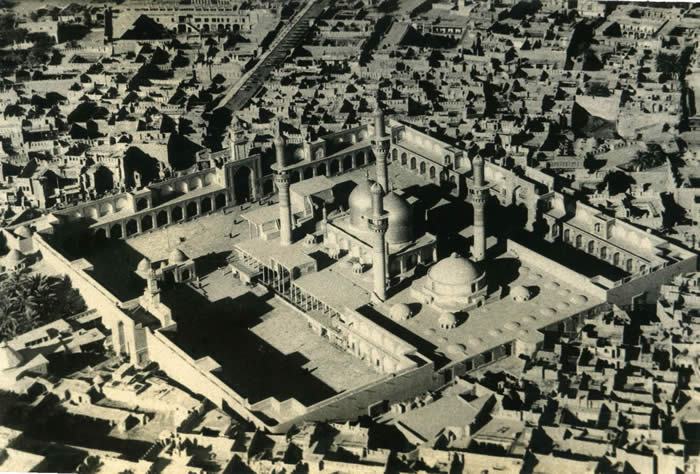
#)Baghdad,which is also called asBagdad, is the capital city of of Iraq
#)Baghdad is situated in the central Iraq, and on the Tigris River and its view is seen in the image below


#)Baghdad is the center for all modes of transport like air,road and railway, and you can see the image below of the railway station of Baghdad

#)Baghdad is the leading manufacturing city of the country, with oil refineries, food-processing plants, tanneries, and textile mills.
#)The handcrafted wares which are produced in Baghdad are, household utensils, jewelry, leather goods, felt, and rugs, and these can be purchased in the bazaars.
#)These bazaars have been a feature of this city and it consists of rows of small shops or stalls.
#)The picture below shows the busy Baghdad Market.

Lets know its History
#)The city of Baghdad was built by the Abbasid caliph al-Mansur in 762 on the western bank of the Tigris River, opposite an old Iranian village which is also named Baghdad.
#)The original city was in a round shape, with three concentric walls of which the innermost wall enclosed the palace of the caliph, the second wall was defined by the army quarters, and the homes of the people occupied the outermost enclosure.
#)The merchants' quarters, which is also called as bazaars, were located outside the city walls.
#)Within 50 years the city reached a peak of prosperity and influence under the rule of caliph Harun ar-Rashid, whose reign is celebrated in the famous tales of the Arabian Nights.
#)It was during this period the city expanded to the eastern bank of the Tigris, and naturally it becomes the heart of.
#)The city of Baghdad remained an important center of trade and culture for more than four centuries.
#)It was during 1258,Hulagu, the grandson of the Mongol conqueror Genghis Khan, sacked the city and it led to the decline of Baghdad and it also put an end to the Abbasid caliphate.
#)Again in 1401 the Turkic conqueror Tamerlane sacked the city .
#)It was in 1508 Baghdad was brought under Persian control and was captured by the Ottoman Empire in 1534.
#)Again the Persians recaptured the city in 1623,and they manage to hold it till 1638 for 15 years, when it was again annexed by the Ottoman Empire.
#)The Ottoman governors ruled the city thereafter for almost three centuries .
#)In 1917 it was captured from the Ottomans by British forces. In 1921 Baghdād was designated the capital of the newly created kingdom of Iraq, which became a republic in 1958.
War in Iraq
#)Baghdad city suffered heavy damage from bombing during the Persian Gulf War in 1991, and again during the 2003 U.S. invasion of Iraq
#)It was in mid-April 2003, as U.S.-led forces captured Baghdad and they overthrew the regime of Saddam Hussein, looters ransacked many stores, government buildings, and museums.


#)Although U.S. forces guarded the government’s Oil Ministry, they failed to intervene to prevent the looting, alienating many residents of Baghdād in the process.
#)The U.S. occupation sparked an insurgency that soon engulfed the city in violence as you can see in the righ image below
#)The largely Sunni Muslim-based insurgency clashed frequently with U.S. forces, as did some of the Shia-based militias that initially opposed the ongoing U.S. presence.
#)As a Shia-dominated government formed under the U.S. occupation, sectarian fighting between Sunnis and Shias resulted in almost daily violenceand it also cost many lives as people were killed everyday
#)Suicide bombings at first were targetted mainly at Iraqi police and military units, after that the attacks began to target Shia businesses and communities, killing and injuring thousands of civilians.
#)These killings were against Sunnis by Shia-led death squads that reportedly operated out of the government’s Interior Ministry.
#)The sectarian fighting had become so severe,by 2007 the,that much of the city’s middle class had fled the city.
#)Entire neighborhoods where Shia and Sunni had once lived peacefully together were uprooted as militias took control of residential areas, forcing residents to move to Sunni-only or Shia-only areas.and it resluted in the daily violence
#)The infrastructure of the city was heavily damaged in the fighting, as bridges became targets of insurgent attacks.
#)Electrical power became sporadic as the terrorist targetted power plants also.
#)The most important was that the city had electricity for only a few hours a day, unless residents organized to purchase and run their own generators.
#)Electrical power failures reflected in curtailing the operation of water-purification plants and shutting down water-pumping stations, lowering water supplies.
#)By the summer of 2007 city officials warned that water shortages in Baghdad had reached dangerous levels.
#)Water became available in most areas for only a few hours a day, and despite the summer heat some areas of the city went without water and people suffered a lotHistorical Places
#)Apart from the war Baghdad does have lots of historical places whic atttracted tourist and in this section lets discuss some of the historical monuments
#)Baghdad also known for his good educational institutions in the city include the University of Baghdad , al-Mustansiriyah University , and the University of Technology (1974).
#)The picture below shows the University of Baghdad

#)Baghdad is also known for its historical monuments and one of the famous Historical structure is the ruins of Bab al-Wastani, which is the last remaining of the famous gates of Baghdad, and is shown in the image below

#)Apart from this the other notable buildings includes Abbasid Palace, which probably dates from 1179, the al-Mustansiriyah, a college founded in 1232 , and both restored as museums, and the Mirjan Mosque, which was completed in 1358.

#)A few miles from the north of Baghdad is the Kazimayn, which is known for its magnificent gold-domed mosque and it was completed in the 19th century and the tombs of religious leaders venerated by the Shia Muslimsand it is shown in the image below

#)The beautiful gold-domed Kazimayn Mosque picture taken at night shown below,

#)The Martyr’s Monument shown in the image below is dedicated to those who died in the eight-year war that Iraq fought with Iran Conflict between the two countries erupted in 1980 and ended in 1988.

#)Hai friends in this artilce let us discuss about one of the beautiful place in the earth and it is one of th ebest tourist spot and it is considered as heaven by the tourists.
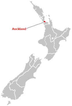
#)Thisis none other than Auckland,New Zealand.

#)Auckland city is situated in the northern part of New Zealand
#)Auckland was founded in the year 1840, and it was considerd as the capital of colonial New Zealand.
#)But in 1865 the capital was transferred from Auckland to Wellington.
#)Auckland achieved its city status in 1871.
#)It is situated on an isthmus which joins the northwestern North Island and the North Auckland Peninsula.
#)It borders on Manukau Harbour ,which is considered as an arm of the Tasman Sea, and Waitemata Harbour ,an arm of the Pacific Ocean.
#)The city consists of several extinct volcanoes within its boundaries, and is a seaport and a naval base and a fishing, commercial, and manufacturing center.
#)The main products of the metropolitan area includes iron and steel, processed food, machinery, textiles, clothing, motor vehicles, forest products, and fertilizer.
#)There are some important places to visit when you go there are
- The Auckland City Art Gallery, which consists of collection of paintings by European and New Zealand artists, and it is shown in the image below

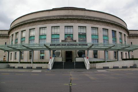
- The Auckland Institute and Museum, which features exhibits on natural history and ethnology
- The Melanesian Mission Museum

- The Museum of Transport and Technology,called as MOTAT,it is New Zealand's largest and leading transport and technology museum and situated within 40 acres, MOTAT will take you on an interactive journey through many of the technological achievements that have helped shape New Zealand.

- Parnell Rose Garden, an great venue for wedding, event or corporate function and it is located just 5 minutes from downtown Auckland

#)The University of Auckland and also Auckland Institute of Technology are some of the great institutes located here,The picture below is that of the University of Auckland

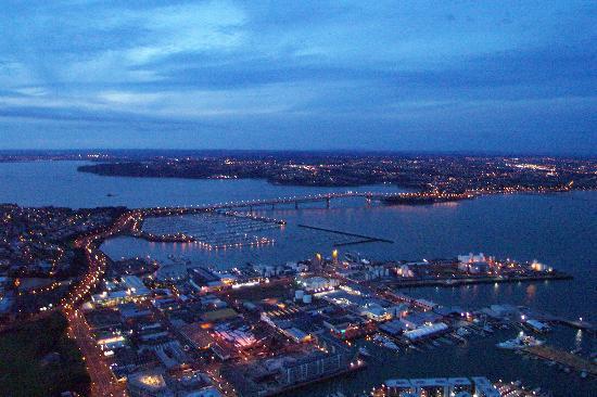
#)Auckland Harbour Bridge is the longest of several bridges linking the central city with its fast-growing suburban areas and it is shown in the picture below, which can be seen from different view

#)New Zealand's main international airport is present in Auckland.
#)Many Pacific Islanders started to move towards Auckland after the end World War II in 1945, and the urban area also contains a large number of Maori, descendants of the pre-European inhabitants of the country.
#)So once in a life time we must visit Auckland........
Page 18 of 22