The story of Atlantis in a nutshell is a riddle wrapped in a mystery inside of an enigma. However, Atlantis is no small, run-of-the-mill mystery. The alluring appeal of this story of a sunken civilization serves a truly powerful cocktail of fact and fiction, myth and history, legend and allegory and last but not the least natural and supernatural. The combination and juxtaposition of so many crucial elements within the confines of one single saga makes for a truly gripping read and still inflames the chariot of curiosity of an octogenarian much the same way it does that to an adolescent even today. However, what makes the mystery of Atlantis so special is the fact that scientists and explorers alike are still at loggerheads in determining whether this tale of a Utopian society is indeed true or the entire story is a subtle premonition to all the future civilizations in the form of a grandiose allegory.
Quite unlike other legendary civilizations whose genesises have either been lost or are still shrouded in the labyrinthine passages of time, the storied details of Atlantis and its very origin can easily be traced to two of Plato’s works that is, “Timaeus” and “Critias” written about 330 B.C. However, the original story actually predates even the life and career of Plato. This lost civilization was said to have existed some 9000 years before Plato’s time which placed it within the furthest corner of remote antiquity. According to Plato the story had been passed down for generations by poets, priests and many others. However, Plato’s account of Atlantis is the only known source of information to us so far in this regard.
According to Plato, this highly advanced civilization was located beyond the “Pillars of Hercules” (Strait of Gibraltar) on an island in the Atlantic Ocean with a combined size more than that of Libya and Asia put together. Clearly it must have been an island continent floating in the Atlantic Ocean if we are to go by Plato’s account in this very context. To begin with, Atlantis owed its origin to Poseidon (the Hellenic God of Sea) who consorted with Cleito and had five sets of twins out of their wedlock. The island continent and the surrounding ocean were named after their firstborn, Atlas. The capital of the island continent i.e., Atlantis stood out for its architectural brilliance and innovative engineering. Everything was going well in this prehistoric Elysium when some 9000 years before the time of Plato decadence and moral bankruptcy started to take firmer roots within the inhabitants of this island continent, who were otherwise a technologically sophisticated race. Being enraged at what they saw the Hellenic Gods decided to teach them a lesson which would take the Atlanteans beyond all sorts of redemption and salvation. A violent earthquake combined with cataclysmic tidal waves arising out of a possible tsunami dealt a death blow to this archipelago and the island nation sank within the span of a single day into the unfathomable depths of the sea to be seen never again. And thus ends the physical existence of Atlantis from the face of the Earth.
However, much like a hydra-headed monster, the mystery of Atlantis resurfaces again after passing almost two millennia of hibernation that borders on near-anonymity. But with the publication of Atlantis: the Antediluvian World in 1882 Ignatius Donnelly truly set the cat among the pigeons afresh by hypothesizing that all known civilizations of yore must have descended from one technologically advanced, superior culture namely Atlantis. Donnelly was not content with yet. And his outrageous claims soon assumed a biblical proportion as he audaciously drew parallels between the Great Flood mentioned in the Bible with the one that eventually destroyed and wiped out this so called fountainhead of almost all the prominent ancient civilizations. Donnelly’s theory received much acclaim and triggered a chain of occultists and theosophists alike whose voices resonated with ideas linked with that great lost civilization called Atlantis.
Other noted personalities who not only took up the cudgels for Atlantis but were also credited with adding a distinct speculative spin of their own to this entire saga of fact and fantasy included occultist Madame Blavatsky ("The Secret Doctrine", 1888) and psychic Edgar Cayce. Cayce made a series of startling predictions connected with Atlantis. He also alleged to have predicted that Atlantis would rise again during the decade of 1960 which triggered a wave of popularity surrounding the mystery of Atlantis. Another tantalizing remark of Cayce informed us that there is a "Hall of Records" beneath the Egyptian Sphinx, which holds the historical texts of Atlantis.
The story of Atlantis and its spin offs were so powerful that the impact of its spillover could be noticed even in other fields of work notably in English literature. The concept of an imaginary, idealistic world only to be used as a benchmark for other future civilizations captured the imagination of common mass as well as the writers of Renaissance period. With Sir Thomas More the “Utopia” (1516) came into being only to connote a Platonic idealistic land where men and women are accepted as paragon of virtue. “The New Atlantis” (1626) by Francis Bacon, though unfinished, is another addition in the tradition of Sir Thomas More’s “Utopia”. The title of the work by Bacon is, quite understandably, an allusion to the mythical land mentioned by Greek philosopher Plato in his works “Timaeus” and “Critias”.
It is a sheer irony of fate that in spite of having so much of information about Atlantis we are still at odds even over the specific location of the destroyed metropolis and its adjoining areas. And it is truly confounding to note that the same set of information (Plato’s account) has led to so many differing interpretations and opinions on the same subject and its specifics. The entire matter assumes a proportion of incredulity when taken into account the mind-boggling advancements made in oceanography and ocean floor-mapping technology. Possible locations of Atlantis range from Atlantic Ocean to Mediterranean Sea to Europe to Indonesia to Bermuda Triangle again. Even some have opined that Antarctica might be the possible site of the apocalypse. However, in concrete terms nothing has so far been discovered that comes even close to being called Atlantis. It is totally understandable that our oceans do contain as well as suppress a lot of arcane information yet given the progress made in the field of oceanography how is it possible to hide a landmass that is more than the size of Asia and Libya put together is a very pertinent question.
Among all the probable sites for Atlantis the one which comes closest to Plato’s description in terms of scientific acceptance is the Greek island Santorini (ancient Thera) where volcanic eruption puts paid to the Minoan Empire around 1500 B.C. The Minoan civilization had all the matching characteristics of Atlantis mentioned by Plato in his works. However, in order to match Atlantis with that of Minoan civilization we have to address one big “if”. According to Plato the island Kingdom of Atlantis disappeared some 9000 years before his time while the Minoan Empire was almost a contemporary civilization of Plato. This glaring mismatch in historical period has been explained by some Atlantean experts as mere anachronism on the part of Plato and nothing else. However, in doing so other relevant information starts to contradict and we end up exactly where we started in the beginning.
This apparent failure to locate this island of continental dimension has led many to question the historicity of the entire account afresh. According to this school of thought the entire Atlantis thing is a moral fable designed to serve a Delphic premonition to all the future civilizations about the perils of moral decadence and decrepitude. Explanations come and explanations go but the story of Atlantis like the pole star remains elusive and yet constant. Unless and until we find satisfactory answers to all the questions, the mystery and conundrum of Atlantis will continue to tease and haunt us forever. I believe the answer remains seated in the womb of future and thus the mystery remains…………………...
Background.
One has to search the map of modern Russia for Leningrad, but it does not exist on Russian contemporary maps. During the days of communist rule the city of St. Petersburg had been renamed as Leningrad, in honor of the Soviet dictator Vladimir Lenin who had led the Russian revolution in October 1917. After the collapse of communism, the Russian government renamed the city with its original name Petersburg. Never the less I shall use the name Leningrad for the purpose of this article.
In 1938 Hitler signed the non-aggression pact with Russia and the Russian foreign minister Molotov was in Berlin to sign the accord. This was a master stroke by Hitler as in one swift act he had secured his Eastern front and thus could concentrate on defeating France.The peace between Russia and germany was however not destined to be eternal as Hitler had made up his mind of waging war against the Soviet Union. The leader of Russia at that time was Josef Stalin, but he grievously underestimated the German threat. This is difficult to understand now as even a cursory reading of Hitler's " Mien Kampf" would have shown him that Hitler always looked for lands in the East to settle Germans and also for raw materials.
The ice was broken on 22nd June 1941, when 3 German Army groups were ordered to move deep into the Soviet Union. More than 2.5 million men along with guns, tanks and aircraft mounted the greatest invasion in world history, dwarfing even the invasions of Genghis Khan. The Russians under Stalin were caught with their pants down and suffered massive defeats.
The invasion of Russia was also inevitable as both Stalin and Hitler looked to dominate the world and as one knows only one sword fits a scabbard. Stalin represented a warped form of the communist theory of Karl Marx. In classical Marxism, the communist guru had envisaged a " Dictatorship of the Proletariat". Unfortunately Stalin headed a government that in effect was a " Dictatorship of the Communist party". Hitler on the other hand subscribed to a theory of National Socialism, which in effect was a race theory that propagated the superiority of the German people.
Never the less teh seeds of conflict were sown long back. The German armies made swift progress and by end 1941 were deep in Russia and were within hand shaking distance of Moscow. They had also converged on Leningrad and Hitler expected its imminent fall and Capture. Hitler was initially keen for the capture of Leningrad, as the city had a fond association with the Russian revolution.
The Siege
The commander of the German Army group tasked with the capture of Leningrad was Field Marshal Wilhelm von Leeb. He was part of Army Group North. He made swift initial progress and by 9th August was just 75 miles from Leningrad as he crossed the Luga river. From the north the German allies the Finns also moved in and to Hitler it appeared a matter of time before Leningrad was captured.
The commander of the German force was Field Marshal Von Leeb. He surrounded the city and yet the German assault did not take place. The reason was the changed priority of the Fuhrer, who withdrew large numbers of Panzers from Von Leeb's force to attack in the south and capture the Caucasus oil fields. The Russian commander General Gregory Zhukov also visited Leningrad and beefed up the defences. The Russians prepared for a long siege.
In march 1942, an exasperated Hitler removed Von Leeb. he was replaced by Field Marshal von Kuchler. In the meantime severe fighting continued in the suburbs of Leningrad. Kuchler advocated a tactical withdrawal an counterattack. Hitler i not like the idea and replaced Kuchler with Field Marshal Von Manstein. Yet the Germans could not make headway against stiffened resistance under command of general Meretskov. Areas frequently changed hands, but the Germans were unable to break into Leningrad.
As the Russian and German armies fought on the periphery of the city a harrowing tale of hunger and famine swept the city. It is now estimated that over 1 million russians died of hunger out of a city population of 2.6 million. Yet, the Russians were not ready to throw in the towel.
The only supply line was across the Ladoga river, which was frequently bombed by the German air force. At this time Stalin showed his leadership qualities by holding and taking the salute at a military parade, with the german army at the gates of Moscow. This was a tremendous morale booster and the Russian resistence stiffened.
In september 1942, Meretskov launched an offensive, but Manstein stopped it. Hand to hand fighting continued in the suburbs, but by January 1943, the situation turned better for the Russians. Four Russian armies under Marshal Leonid Govorov mounted an assault and pushed the germans back. The supply position improved and oil and fuel for the city population was transported to Leningrad. The Russians also made the train line operational and despite attacks by the Germans the situation improved radically.
The defeat at Stalingrad had an effect and the Rusians mounted an offensive and broke the German siege. On 27th January 1944 the rail line from Moscow to Leningrad was recaptured by the Russians and the siege was officially declared over. It ha been a tremendous battle of wills and the Russians were the winners
Last Word
The siege of leningrad lasted 907 days and is a tribute to human endurance. It ranks on a par with the long march of Mao tse Tung covering 6000 km when retreating from the Nationalists. The Leningrad siege is an example of the human body can achieve. It brings out the spirit of the Russian people and the ingrained hardy character. It's not something one can associate with Indians who allowed them to be ruled for 900 years by a small coterie of Muslims and Turks. Only if the Hindus had shown similar reliance and courage, they would never have been slaves in their own land.
The siege was also a battle between two formidable dictators Hitler and Stalin and it is recorded that Stalin won. This man is now a much respected figure in Russia as the people yearn for the days when Russia was a great power under Stalin.
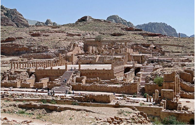
The ancient city of Petra, also known as Rose-red city, is one of the most renowned archaeological sites in the world, and the greatest tourist attraction of Jordan. The towering structures of Petra, half-built and half-carved into the rock, surrounded by mountains and passages, remain as a magnificent architectural wonder of the Nabataeans. In the heart of the desert, Nabataeans built an amazing civilization with tombs and temples, aquaducts and altars, and halls and houses, and above all, the abundance and magic of ingenious waterway to provide the city with water. The breathtaking landscape covering 26,400 square meter area, situated between the Red sea and the Dead Sea, was the main caravan center for the Chinese silk, Arabian incense and Indian spices and served as an important inter-junction between Asia, Egypt, Arabia, Greece, Rome and Syria.
Location
The city of Petra, visited by millions of tourists all over the world, is located 164 miles south of the capital Amman and 84 miles north of the red sea town Aqaba, in the Arabian Kingdom of Jordan, in Western Asia. It is situated amidst the mountains to the east of a large valley connecting the Dead Sea to the Gulf of Aqaba.
The Golden Era of Nabataeans
The Nabataeans, an Arab tribe, came from the south-east Arabian Peninsula, appeared in the desert located in the east of Jordan, settled in Petra and expanded their regions. Petra was the capital of Nabataeans Empire from 400 BC to 106 AD.
The two trade routes, one from the western Asia and the other from the Southern Arabia, meet at this inter-junction. The Nabataean rulers collected taxes and the trade improved in the areas of incense, textiles, ivory, precious metals and spices. Caravans were used in the land trade and ancient sea vessels known as dhows were used in sea trade. The trade routes linked India, China and southern Arabia with Greece, Egypt, Syria and Rome.
The Nabataeans had great skill in irrigation and water technology. With their engineering expertise they collected water in pools and cisterns and distributed to the whole city using well designed engineering conduits. It is estimated that they handled about 40 million liters of fresh water per day which is capable for supplying to a modern city consisting 100,000 people.
Thus Petra offered the traders and caravans to take rest and fill their water supply needs at a fee. They controlled the trade, levied tolls for a safe business culture and became very rich and powerful in caravan trade during the third and second centuries BC. During another 400 years they expanded their facilities, beautified the city with tombs and temples, residential and commercial buildings, thus making the ancient Petra one of the wealthiest cities in the world. With the influence of Egyptian, Syrian, Roman and Greece characteristics they created structures of architectural marvel arduously cut into sandstone rocks.
The City under Roman Rule
Realizing the power of Rome, the Nabataeans made an alliance with the Romans to suppress the Jewish revolt in 70 A.D. And finally, based on a deal between Rabbel II, the last Nabataean monarch, and the Romans, the entire Nabataean empire came under the control of Roman Empire in 106 A.D. Romans redesigned the city with traditional Roman architecture, and carved many buildings and structures. Under the Roman rule, Nabataeans continued their own religious practices until 324 A.D. when the Roman Empire proclaimed Christianity as their religion. Under Byzantine Empire, Christianity continued for another 300 years showing a slow decline of the Nabataean culture.
The Lost City
In 661 A.D. the city of Petra fell under the rule of Islam and the commercial importance became completely lost. Following a series of earthquakes in 693 A.D. and later many of the buildings were destroyed and the water management systems and commercial infrastructures were demolished. After the establishment of Abbasid Caliphate in 750 A.D. the city of Petra was completely disappeared from the historical records, thus giving it the nickname of the ‘Lost City’. Faded from the memories of the West for more than thousand years, this incredible city was literally ‘rediscovered’ in 1812.
Petra Rediscovered
In 1812 Johannes Burckhardt, a Swiss adventurer set off to rediscover the lost city. Heard from the desert Bedouins about the ruins of an ancient city, Burckhardt, who was fluent in Arabic and dressed up as an Arab traveller, sought guidance of his Bedouin guide to lead him to the Lost City. After his rediscovery, this magnificent ancient city became known to the west and became one of the most visited tourist attractions of the world.
Major Attractions
With their amazing skills in architecture and engineering, Nabataeans created a city of intricately carved structures , temples, altars, banquet halls, facades and about 3000 tombs, all cut into the rose sandstone cliffs of Jordan. Few of the attractions are discussed here.
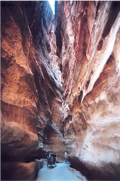
Siq: Entrance to the city is through a long passage called Siq, which can be reached by walking through ‘Bab Al Siq’ consisting of several monuments. Siq is a narrow gorge leading to the ‘Treasury’, with the widest portion measuring 5 meters, with walls standing at 100 meters high on both side and leading upwards through more than one kilometer. Many historic remnants can be seen in this entryway, including a paved road now covered with soft sand, sacred stones, colourful patterns of sandstone and sculptures of caravan of camels and men.
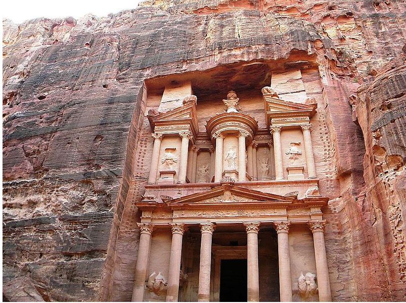
Treasury: Siq leads to the Treasury, which is more than 40 meters high, and is one of the magnificent structures carved out of solid rock of the mountain. Also known as al-Khazneh, the purpose of this structure is still a mystery. May be it was a royal tomb or a temple. Bedouin belief was that large amount of valuables and treasures were hidden here by pirates; hence the name treasury. The front portion of the treasury was adorned with sculptural decorations of ancient god figures. There was a 12 square meter inner chamber and a space for ritual washing.
Street of Facades: After the next turn there appears the Street of Facades, also known as Outer Siq, lined with facades of Nabataean tombs magnificently carved in the cliff of the outer Siq.
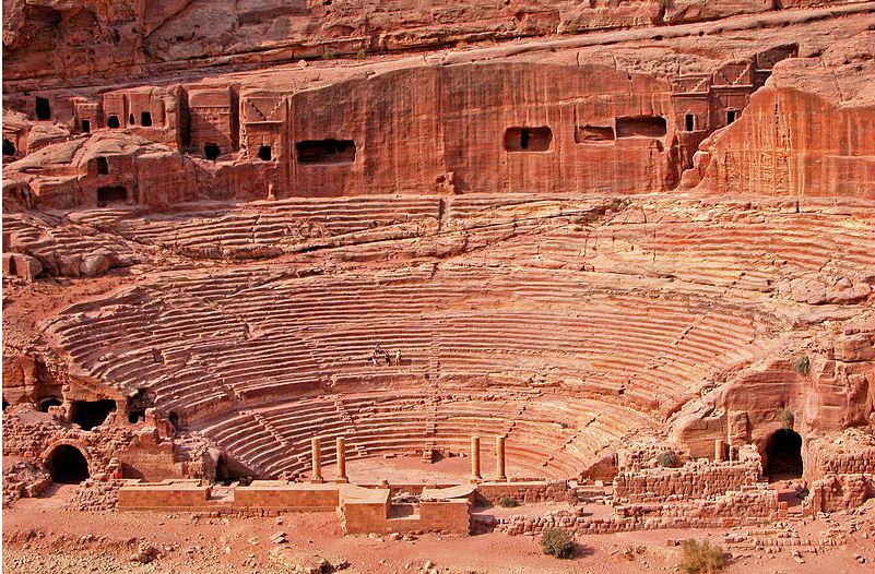
Theater: The Theater of Petra, carved entirely out of solid rock into the side of the mountain, was built by the Nabataeans in the first century AD well before the establishment of Roman rule. With a capacity of over 8000 spectators, the multi-rows of seats were separated by passageways and with stairways to ascend to the auditorium. The wall behind the stage was rebuilt by Romans. A large number of Royal tombs can be seen on the opposite side of the Theater, on the side of a valley, which is at a short walk up the hill.
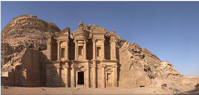
Monastery: The Monastery or Al Deir is one of the largest structures in Petra and the most spectacular among all the structures. The temple is wonderfully carved completely out of red sandstone, with 45 meters high and 50 meters wide. The entrance door is 8 meter tall. The single empty chamber of 125 square meters area with plain walls is provided in the back wall with a block of stone symbolized as the deity Dushara. The main deities of the Nabataeans were Dushara, Allat and Al-Uzza. The flat courtyard in front of the temple was capable for accommodating thousands of people, indicating extensive ceremonies of those periods. In addition to the religious worship practiced by the Nabataeans, it was served as church during the Roman rule; hence the name The Monastery.
The Great Temple: The Great Temple of Petra is a two-level structure, discovered by the archaeologists of Brown University in 1992. Built in 1st century BC to 1st century AD, it was supposed to be used as a large palace and assembly hall. It is the largest free-standing building covering an area of 7560 sq.meters. The Lower Temenos, enclosed on the east and west side, accessed by stair cases and paved with hexagonal stones, are triple colonnades with a total 96 to 120 columns. Each colonnade leads to a small apse, where carving of several art crafts were found, including lamps, coins, ceramics and elephant.The proper temple is on the Upper Temenos, with walkways leading to it from the east and west. The temple is faced by a facade with four columns, and a semicircular assembly space in the center of this area.
In addition to these wonderful remnants of the ancient city, there are many more remarkable attractions that will provide magical moments to the visitors.
How to reach there
The two main international airports in Jordan are: Queen Alia International Airport (Amman) and King Hussein International Airport (Aqaba). From airport you can take taxi directly to Petra. Or from the airport you can reach Amman or Aqaba by Taxi and from there by public buses to Petra. It is a 3 hour journey by bus from Amman to Petra; and it takes 2 hours from Aqaba to Petra.
When to Visit
Petra is open to visitors daily from 6 am to 6 pm during summer and 6 am to 4 pm in winter. Best time is to start in the early morning, enjoying a comfortable stay in any one of the good hotels available in Petra.
Conclusion
This UNESCO World Heritage site was declared as one of the New Seven Wonders of the World, on July 7, 2007. Petra has been chosen by Smithsonian magazine of Washington D.C. as one of the 28 wonderful places in the world that we should never miss to see in our lifetime. The civilization that existed in Petra 2000 years ago was amazing and unique. Though capable of writing, as ascertained by the archaeologists, these people have left no written records of their mysterious era. After vanishing from the pages of history for more than thousands of years, the Rose-red city has returned, but leaving all the secrets and magic beyond the reach of time.
Image source: Wikimedia Commons
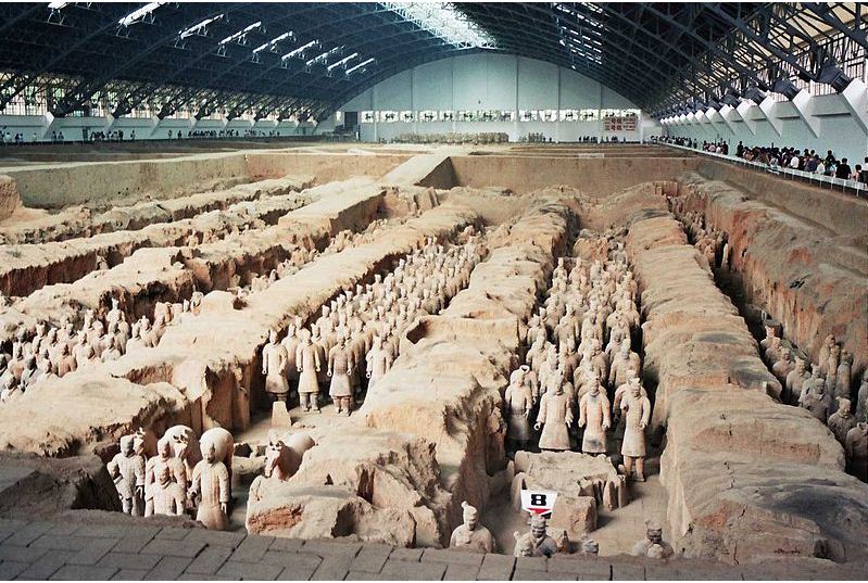
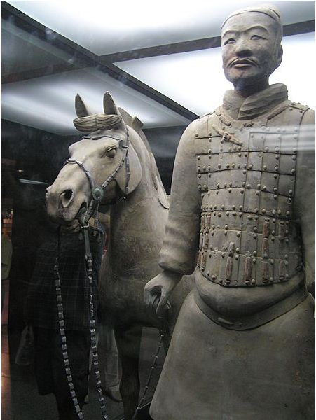
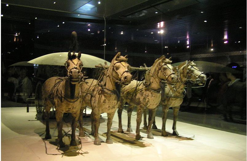
The Terracotta Army of warriors and horses is one of the greatest archaeological excavations of the 20th century. It is a collection of life-size terracotta sculptures of soldiers, horses and chariots, representing the armies of Qin Shi Huang, the first Emperor of China. The figures of the Terracotta Army estimated as more than 8000 warriors, 150 horse regiment and 130 chariots with 520 horses were buried in the three pits nearby the Emperor Qin Shi Hunag’s mausoleum, in the third century BC, and were discovered by local villagers of Xian in 1974, after more than 2200 years.
Location
The archaeological site of Terracotta Army is located about 1.5 kilometers east of the Mausoleum of Qin Shi Huang, in Lintong District, Xian. Xian, the capital of Shaanxi Province, is located in the central region of China in the Asian continent.
History
The first Emperor Qin Shi Huang, from whom China got its name, started work on his mausoleum soon after he ascended the throne at the age of 13, in 246 BC. The favoured site chosen to construct his burial place was at the foot of Mount Li. Involving the hard work of 700,000 workers from every province of the empire, an underground city was constructed within an enormous mound. This concealed architectural wonder was an exact model of the palace and the empire and its vast treasures were protected by automatically activated weapons designed to keep off robbers.
After his death, the Emperor Qin Shi Huang was buried with his palaces, treasures and the sculptures of the army. It was believed that all the valuables and treasures would accompany him after his death and the statues would be animated in the afterlife when the emperor required an after-death army to protect him.
In 1974 a group of local villagers, while digging wells near the emperor’s tomb, uncovered some fragments of the terracotta warriors and some bronze weapons. This caught attention of the archeologists and a full-scale excavation was carried out in four pits located approximately 1.5 kilometres east of the Qin Shi Hunag’s mausoleum. It was established that the sculptures were associated with the Qin Dynasty of 2200 years ago. The terracotta army consisting thousands of soldiers, chariots and horses of were found buried in the three pits and the fourth pit was found empty. Several pits surrounding the tomb mound have been excavated which contain different figures such as officers, acrobats, musicians, strongmen, laborers, stone armour suits, rare animals bronze cranes and ducks.
Attractions
The mausoleum of Qin Shi Huang is a unique architectural unit, the largest preserved site in the Chinese history. To protect the terracotta sculptures uncovered from the pits nearby the tomb mound, a museum was constructed on the site in 1975. On completion, the museum of the terracotta warriors and horses became one of the greatest attractions of the visitors all over the world.The Museum of the Terracotta Army and the Qin Shi Huang Mausoleum have now been combined into one large area of tourist attraction, called ‘Emperor Qin Shi Huang’s Mausoleum Site Park’. The Terracotta army is listed as a UNESCO world Heritage Site and is now regarded as the eighth wonder of the world.
The museum covering an area of 16,300 square meters consists of mainly three pits and the Exhibition hall of bronze chariots. Life-size terracotta sculptures of the warriors and horses arranged in battle formations are the great attractions in the museum.
Pit No.1: Discovered by the local villagers in 1974, it is the largest pit with 230 meters long and 62 meters wide and contains the main army of more than 6000 terracotta statues of soldiers and horses. It has 11 corridor paved with bricks and is provided with a wooden ceiling. It was first opened to public in 1979. It is now completely enclosed inside the museum at the site.
Pit No. 2: Discovered in 1976, it is 20 meters north-east of Pit No. 1. It contains more than 1500 soldiers and 90 chariots. It represents four units of different battle formations: kneeling and standing archers; a chariot cavalry array; a chariot war array; and a cavalry division with weapons. It was opened to the public in 1994.
Pit No. 3: Discovered in 1976, it is 25 meters north-west of Pit No.1. It appears to be the command center of the armed forces. It contains 68 officers and dignitaries of higher ranking, a war chariot and four horses. It was displayed to the public in 1989.
Bronze Chariots: Two bronze chariots are displayed in the exhibition hall, which were discovered in 1980. Each of these carriages consists of 3400 parts and is driven by four horses. Each weighs 1234 kg, mainly made of bronze, but includes 1720 pieces of golden and silver ornaments weighing 7 kg on each chariot.
Assembly line production: Different parts such as the heads, torsos, arms and legs of the terracotta army figures were produced separately and then assembled to form the life-size unit. Different face moulds were used to create different features of face. It is understood that assembly line manufacturing techniques with high quality control were followed 2200 years ago to produce life-size terracotta army.
Variety: The terracotta sculptures of the warriors are of life-size, and vary in height, uniform and hairstyle, as per their rank. Their height varies with their positions, the tallest being the generals. Facial features and expressions differ and provide a clear picture of the military and cultural history of that period. The figures were painted with different colours to give them realistic effect.
Weapons: Different weapons were found in the pits, including swords, spears, crossbows, battle-axe, arrow heads and shields. The swords have sharp edge, with chromium dioxide coating that kept it rust-free for 2200 years. Manufacturing dates were inscribed on some swords. Studies have revealed that 2200 years ago the people were highly advanced in technology, had high knowledge in chemistry and had used industrial machine tools like lathe and grinding machines.
How to Reach There
Xian Xianyang International Airport is located 40 km northwest of the city centre, in Xianyang. Xian is located in the heart of China, and is well connected by public transport from major Chinese cities. Taxis or the airport bus can be used to reach Xian railway station from the airport; however taking a taxi is not recommended, as most taxi drivers will ask for more fare from tourists. There is a bus every 20 minutes from the airport. From the train station, take tourism bus up to the Terracotta Army.
When to Visit
The site will be fully crowded during the peak season from May to October. Weekends will be more crowded than week days. It is better to avoid the main holidays of China such as National Day (October 1-7), Spring Festival (January/February), and Labor Day (May 1-3).
Conclusion
Over the past several years, discoveries have revealed that the site represents one of the most magnificent archaeological reserves in the world. Thousands of statues of the terracotta army still remain to be discovered from this archeological site. Due to the outstanding technical perfection and the artistical beauty, the terracotta warriors and horses and the bronze chariots remain as the masterpieces in the history of Chinese sculpture.
Image source: http://en.wikipedia.org/wiki/Terracotta_Army
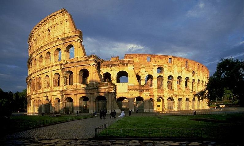
Colosseum, the symbol of Roman power and violence, brings back the memories of gladiator fights into our mind. Gladiators were slaves, criminals and prisoners of wars, who were forced to fight each other using various weapons till one became dominant and killed the other. These bloody fights were witnessed and supported by thousands of exciting Roman spectators of various classes. The tunnels and chambers below the arena created special effects with animals rising magically from the underground, adding exciting moments to the fight. In most cases when a gladiator defeated his opponent, the spectators would give him signals to kill or spare the defeated person. The winner was acclaimed by all and probably attained freedom.
Roman Colosseum symbolizes a lifestyle that prevailed in ancient Rome 2000 years ago. It is the largest monument ever built in Rome and is one of the marvelous works that reflects the creative magnificence of Roman arts, architecture and engineering. This elliptical colossal amphitheater had a capacity of about 50,000 spectators. In addition to gladiator fights, this amphitheater was used for animal hunts, mock sea battles, presentation of famous battles and classical mythology dramas.
Location
Colosseum, the icon of imperial Rome, is a UNESCO World Heritage site and one of the New 7 Wonders of the World, situated in the heart of Rome in Italy. It is one of the most frequently visited historical monuments of Rome and is located next to the Roman Forum and Palatine Hill, another two great sites of the city.
History
Emperor Vespasian was the man behind this masterpiece. When Emperor Nero suicided in AD 68, there were successive civil wars for eighteen months, followed by the ascent of Vespasian as the first emperor of Flavian Dynasty. Vespasian decided to build the Roman Colosseum, the master piece of Flavian dynasty on the site of the Golden House of Nero. The construction started in AD 70 and was finished in AD 80, just one year after Vespasian’s death and was opened to the public by his eldest son Titus. Originally known as Flavian Amphitheater, the name Colosseum was derived from a colossal statue (the Colossus) of Emperor Nero that stood on this area.
The fight and blood shed of gladiators and animals that gave violent entertainment to the Romans continued for about 450 years. Christianity spread in Roman Empire and a law was enforced in A.D. 404 by Emperor Honorius to abolish the gladiator fight, but the animal fights continued for another hundred years. With the growth of Christianity, the popularity of the bloody combat and the importance of the Colosseum gradually declined, and the people of Rome gradually relieved from the harsh memories that dominated their city for over 450 years.
Design & Architecture
Colosseum was built with an elliptical shape, 189 meters long and 156 meters wide, with the outer wall of 48 meters tall. It has a perimeter of 545 meters and an area of 24,000 square meters (6 acres). The oval shaped central arena is 87 meters long and 55 meters wide and with a 5 meters high surrounding wall.
The building materials used to build this huge concrete structure were cement, travertine stones, bricks, tile and marbles. High skilled workmanship and standard were accomplished throughout the construction.
Exterior
In the exterior, there were three stories consisting of superimposed arcades and a fourth story having window openings. There were 80 arches in each of the three-tiered stories, with statues in the arches of the second and third floor arcades. There were eighty entrance gates for the spectators, 76 of them for ordinary spectators and the four VIP entrances for emperors and elite persons. On the top of the building was a paneled awning, called Velarium, which served the purpose of a shade to protect the spectators from the intense heat of sun.
Interior Seating
The total capacity of the Colosseum was 50,000, with 45,000 sitting spaces and 5000 standing spaces. Tiered seating arrangements were provided for the different classes of spectators, classified as per their status in the society. The most important persons including emperors, senators, vestal virgins and priests were seated on the first tier called Podium, starting at 4 meters above the arena. Other noble class, including knights, were seated on the second tier known as the ima cavea. Better lower seats of the third tier, or the media cavea, were reserved for ordinary but wealthy Roman citizens and the upper seats of the third tier were reserved for the poor citizens. The fourth tier, the summa cavea, with wooden seats of the gallery running around the theater up to the very top wall, were meant for the common poor, women and slaves.
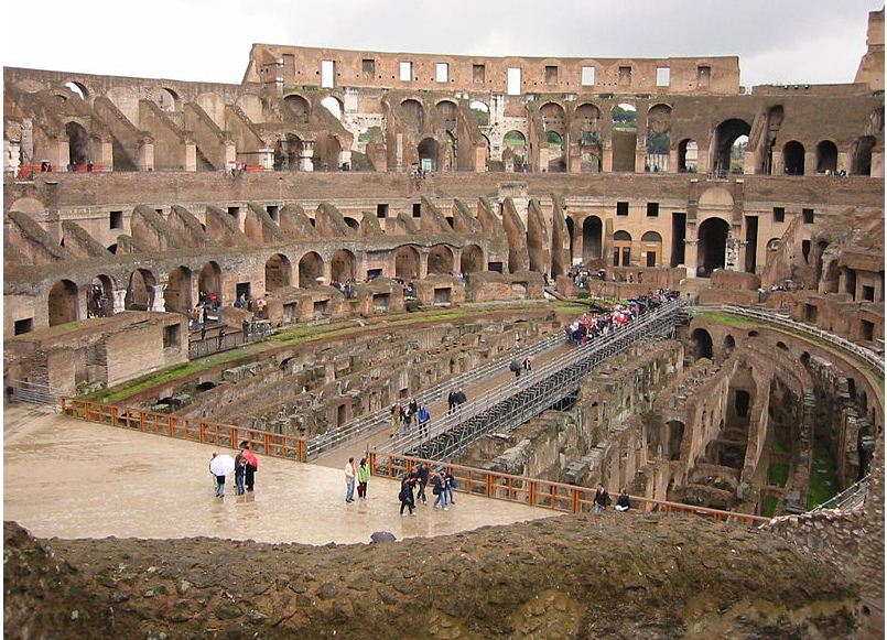
The Arena
The original floor of the arena was a wooden floor covered by sand with an intricate underground structure, which is known as hypogeum. The hypogeum had two-level concealed tunnels and 32 animal cages. The animals had instant access to the arena through 80 vertical shafts and pulleys. The tunnels provided access to various areas including the training school of gladiators and to the rooms where weapons and equipment were kept. There were several machinery including hydraulic mechanisms that could be used to flood the area quickly for mock navel battles.
Safety
Since the games inside were very dangerous, several protective measures were provided for safety. A huge wall of 15 feet high, faced with marble, were provided to separate the arena from the seating areas, to prevent the violent animals from climbing and reaching the royal people on the podium. A large trench was also provided for more safety.
How to reach there
The Roman Colosseum is situated in the centre of the city. Leonardo da Vinci/Fiumicino International Airport is the main airport of Rome. It is well connected to the center of the city by public transport. Ciampino International Airport, located to the southeast of Rome, is a low-cost airline airport. Colosseum is easily accessible from both the airports using public transport by bus, tram or metro.
When to Visit
Summer season is the best time to visit the Colosseum. During winter, the underground area will be flooded and will make the visit a difficult task. The Colosseum is open for visitors from 8:30 a.m. until one hour before sunset every day, except on Christmas and New Year days. All the three attractions, the Colosseum, the Roman Forum and the Palatine Hill can be visited under a single admission ticket, valid for two days. From 2011 onwards, the underground chambers and the third tier of the Colosseum were also opened to public, which were closed for decades.
Conclusion
Serving as the entertainment centre of Rome for more than 450 years the Colosseum was subject to many repairs and restoration work. Major repairs were carried out when fire struck the higher storeys in 217 AD, and after earthquakes in 443 and 484 AD. Restoration works were carried out to maintain the classic nature of the Colosseum, the recent one being a massive restoration project completed in 2000. A major restoration work is being carried out now, to be completed by 2016. Even today, when fully lit from within the massive structure on a dark Roman night, this great monument will take the visitors back to 2000 years ago and the clashing sounds of the swords of the gladiators will rumble in their ears.
Image source: http://commons.wikimedia.org/wiki/Colosseum
More Articles …
Page 1 of 22